Helping Communities Prepare As Flooding Becomes More Frequent
Scientists have known for a long time that major floods are becoming more common.
September 1, 2017
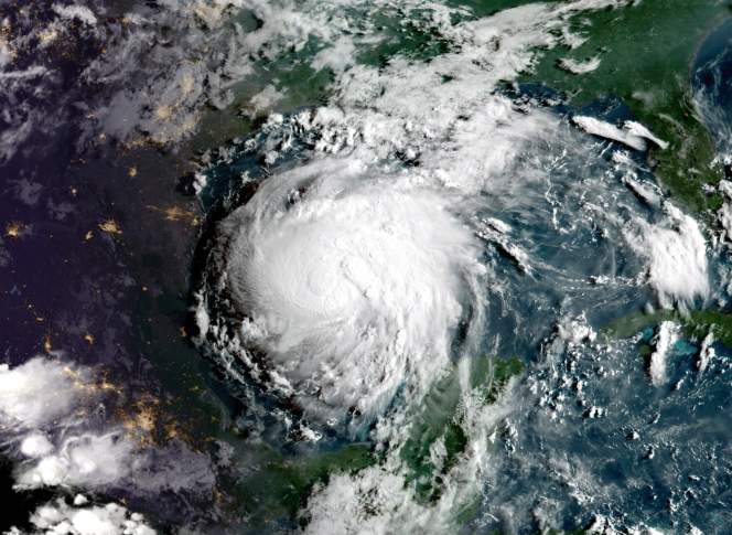
Satellite image of Hurricane Harvey approaching Texas coast

The sheer amount of water Hurricane Harvey inflicted upon southeast Texas in late August 2017 astonished even people who study floods for a living. Shane Hubbard, a postdoctoral researcher with the University of Wisconsin-Madison’s Space Science and Engineering Center, analyzed the data about Harvey’s impact and determined that thousands of square miles across the Houston area experienced flooding on a truly historic scale
“This is something that hasn’t happened in our modern era of observations,” Hubbard told The Washington Post.
As unprecedented as Harvey is, scientists like Hubbard have also known for a long time that major floods are becoming more common. He discussed the challenges posed by flooding in a Jan. 4, 2017 talk for the Wednesday Nite @ the Lab series on the UW-Madison campus, which was recorded for Wisconsin Public Television’s University Place.
Hubbard has analyzed data on the increasing prevalence of flooding across North America. Much of his work focuses on helping communities get the information they need to plan for the impacts of floods.
Attitudes about flooding have gradually changed, Hubbard explained. Throughout history, engineers and governments tried to build ever taller and wider levees to keep floods at bay. But in the 1960s, researchers began to question that approach and started thinking more about getting people away from floodplains and out of harm’s way. This shift led to policies addressing flood insurance and establishing scientific benchmarks like flood return frequencies.
Of course, as Hubbard lamented in his January talk, there are still plenty of homes, businesses and environmentally sensitive industries like chemical plants in flood-prone areas around the globe, as Harvey’s impact in Houston so tragically demonstrates.
Hubbard also offered an overview of how flood preparation works, from the stability of building materials to storm sewer engineering to emergency management. He discussed how the engineering tools for dealing with floods are evolving, considered the economic and human toll of floods, and detailed the work he’s done trying to help low-income communities in Puerto Rico become more resilient in the face of frequent flooding.
Key facts
- The entire continental United States saw an increase in heavy rainfall events between 1958 and 2012, with the biggest spikes in the Northeast and Midwest. Presidential disaster declarations have also been issued on a more frequent basis since the 1950s.
- Damage losses paid out by the Federal Emergency Management Agency saw massive spikes in the wake of Hurricane Katrina in 2005, a nationwide year of floods in 2008, and Hurricane Irene in 2011.
- The damage floods do goes far beyond wrecking buildings. Wastewater systems can be disrupted during floods, and drinking water sources can be cut off or made non potable. Communities can also lose power for days at a time. In the Midwest, floodwaters can sweep up agricultural chemicals that people have stored in facilities in flood-prone areas.
- Identifying flood risks requires a complex analysis of infrastructure and hazards. For instance, not all buildings in a floodplain are necessarily at risk in a flooding event. Moreover, developing adequate data sets for flood preparation often requires drawing on multiple information sources.
Key quotes
- On the increased frequency of floods: “We know that flooding is changing, people can feel that. Seems like you turn on the TV anywhere from February through July, and every week, once a week you’re seeing a community that’s fighting floods.”
- On the increasing societal impact of floods: “It’s not just how deep the flooding is or how intense it is, but where it is occurring. So if there are more buildings there, there’s going to be more damage.”
- On how different kinds of floods allow different amounts of time to plan a community’s response: “You can imagine a flash flood is very different from something that may be rainfall driven over a long period of time, or maybe a storm surge event from a hurricane … Where the rainfall occurs and its intensity is really going to determine that amount of response. If I have a flash flood, I’m really going to think about evacuating people. If I have something that’s a long duration flood or storm surge, I might be able to put up sandbag walls and things to protect property and lives, just not lives alone.”
- On pollution hazards caused by flooding: “The water can be very polluted during a flood. It’s often very diluted because there’s so much water but the amount or the tonnage of pollution is very, very high inside the water.”
- On using complex data to figure out flood vulnerability: “If I know where the buildings are and I know at what level they’re vulnerable, and now I know where the flood water is and how deep it is and what its elevation is, I can combine these two things together using geospatial tools, and I can do an assessment of what is going to be flooded or damaged … [this way] they’re not trying to evacuate all the buildings all at once.”
- On the impact of poor infrastructure in an impoverished neighborhood in Puerto Rico: “Not much is going to be taken away water-wise, and so the result of this is that when they get as little as an inch of rain over a 45-minute time, they have tremendous flooding here, because this was originally a marsh — the water was originally supposed to be absorbed by the marsh or the mangroves, or it was supposed to run to the canal.”
 Passport






Follow Us