Chris (CC BY 2.0)
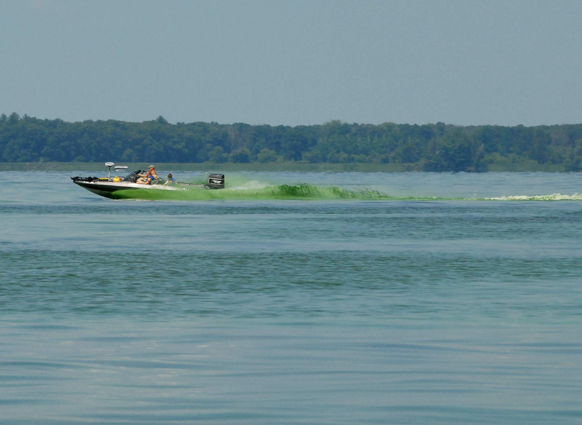
Algae is visible in Castle Rock Lake, located in Adams and Juneau counties, in this photo taken in 2008; the same body of water is on the Wisconsin DNR's 2017 list of impaired waters.

All around Wisconsin, people are feeding a stinky, green and oftentimes toxic life form. Algal blooms are a regular occurrence on Wisconsin's lakes during the summer, and the microorganisms that comprise them need phosphorus to thrive. It's among the essential building blocks of life, but too much phosphorus can throw an ecosystem out of balance.
Excess levels of phosphorus makes its way into waterways across the state, with sources including farm fertilizer and sewage. But to get a better sense of how widespread phosphorus problems are, it helps to look at Wisconsin's "impaired waters" list.
The federal Clean Water Act requires states to maintain lists of bodies and areas of surface waters that are impaired, which means they fall short of certain environmental standards. States share these lists with the Environmental Protection Agency, which must approve them, and keep the EPA apprised of how they plan to tackle each entry's pollution problems. These lists can also help states receive and parcel out funding for environmental remediation.
For the purposes of an "impaired" list and other environmental regulations, bodies of water are often broken up into distinct segments — an area of a lake, a specific stretch of a river — unless they're small. A given body of water can show up more than once on the list if multiple segments are included, or if any one segment exceeds regulatory limits for more than one pollutant.

The Wisconsin Department of Natural Resources announced an update to its list in November 2017 that will add 240 areas of surface water and remove 35. The full proposed list comprises a total of 1,959 listings — many of which are multiple distinct segments of a single river or lake with some segments are listed more than once for multiple pollutants — reaching across 71 of Wisconsin's 72 counties.
The list doesn't offer a full picture of water pollution problems across Wisconsin, because DNR staff and the citizen volunteers who help them can't monitor conditions in every single one of the state's thousands of lakes and rivers, not to mention its more than 800 miles of Great Lakes shoreline and 200 miles of Mississippi River frontage. It means monitoring will potentially miss many bodies of water with pollution problems, as well as those in reasonably good environmental health. The DNR's list also reflects changes in environmental regulations over time, most prominently including the more exacting phosphorus rules Wisconsin adopted in 2010. Additionally, the state has only maintained the list with any regularity since the 1990s.
The impaired waters list is not a perfect tool for gauging surface water pollution in Wisconsin, and is very much a work in progress, but it offers a useful starting point for better understanding the scope of the issue in the state.
Ashley Beranek, who coordinates the impaired waters list as an integrated report coordinator in the DNR's Water Evaluation Section, estimates that about 25 percent of the state's surface waters are assessed for possible inclusion on the list.
"That's because we have 88,000 stream miles and 1.2 million lake acres," she said. "We have a lot of waters in our state — when I map them all, it essentially turns the state blue."
The DNR generally prioritizes testing larger bodies of water, especially ones popular for recreation.
Like other standards and methodologies that go into the list, the way the DNR divides larger bodies of water into segments for monitoring has evolved over time. There's no mathematical formula of splitting a river into sections by a given mileage or a lake by a prescribed acreage. Instead, the agency uses a mix of ecological and geographic factors to determine what section of water is relevant to the list, Beranek said.
Early on, the DNR would designate a certain portion of a river as a body of water for the purposes of the list if its ecosystem included a particularly strong trout population, for instance. Or sometimes waters would be divided using road crossings or county lines, even though "the fish don't really care," Beranek said. Some of these older divisions remain in the list for the sake of continuity.
Currently, the DNR emphasizes habitat in its divisions, for instance if a particular stretch of river has a distinct population of fish or insects, or there are major land-use changes nearby that might affect what pollutants flow into it.
Beranek sums it up this way: "Is the community within this particular stretch of stream different from that which is downstream or upstream?"
Rivers are more likely to be split into sections than lakes, but a lake may be divided as well if scientists determine that a particular section , such as a bay, is biologically different enough from the rest of it.
The trouble for a given body or stretch of water can begin long before it's officially listed as impaired. Generally speaking, an impairment listing means a pollutant has exceeded a certain level. Pollutant standards for surface water don't necessarily indicate how much of a pollutant it takes to harm fish or create bad smells; rather, they reflect a balance of science and political will to devote time and resources to dealing with a given pollutant. For instance, the EPA has set a level of lead content for drinking water that requires action if exceeded, but there's no safe amount of lead for a person to be exposed to.
Regulators can't swoop in every time phosphorus enters a stream, so they set a mathematical level at which they've calculated it's worthwhile to consider intervening. The system of listing and delisting impaired waters reflects these calculations — it's a way of setting priorities.
If the levels of a given pollutant exceeds state or federal water quality standards, that might signal some kind of short-term problem, but might also reveal the consequences of gradual changes in human actions nearby — an increase in industrial activity, problems with nutrient management on farms, heavy use of road salt during the winter and so on.
"Most of the problems build for a long time, whether it's phosphorus, or mercury in fish or PCBs in fish, and it takes a long time to get them off," said Paul LaLiberte, a retired DNR water resources specialist who now works with Wisconsin's Green Fire, a group of volunteer conservation professionals seeking to connect the public and policymakers with solid environmental information as scientific research is deprioritized at the DNR.
For instance, PCBs — a class of industrial hydrocarbons used in various electronic products, building materials, and motor oils — have been banned in the United States since 1979, while numerous regulations over the decades have attempted to curb mercury emissions, but both are still found in fish in Wisconsin. A variety of pollutants have a way of hanging around, and getting them out of the food chain can be a decades-long process. That lingering challenge helps to explain why some bodies of water have been on the impaired-waters list since the late 1990s or early 2000s, LaLiberte said.
When the DNR makes a plan to improve conditions in a body of water it has listed as impaired, it's working within significant limits. The agency has finite staff and budget to address known cases of pollution around the state, and has only become more strained as Gov. Scott Walker's administration and the state legislature have cut its funding and curtailed its regulatory authority.
The state and federal regulations stemming from the Clean Water Act and other state laws don't give regulators broad authority to halt sources of pollution around a troubled lake or river. For starters, it takes time to research pollution sources and put together and receive EPA approval for a mitigation plan, which often takes the form of something called a total maximum daily load, or TMDL. This metric establishes the maximum amount of a contaminant that can enter a body of water without exceeding regulatory limits on its concentration, and sets out a plan for working with polluters to achieve that goal.
Once it has established a TMDL, the DNR can't take the same approach with all polluters. In the regulatory world, pollution has either a point source or a nonpoint source. Point-source pollution comes in large amounts from one origin, such as a wastewater plant's discharge into a river. Nonpoint-source pollution comes from a number of diffuse sources, like when runoff from multiple farms in a given area converges in the river.
If the DNR determines that river is impaired for phosphorus, it has some discretion to crack down on point-source pollution, for instance by enforcing tougher phosphorus limits on wastewater plants in the area. But it has less flexibility when it comes to nonpoint sources, as LaLiberte explained.
"The path for dealing with that with the wastewater discharges is relatively clear," he said. "However, doing something with agriculture … just getting that [plan] finalized and approved by EPA for the recommendations of what should happen with agriculture doesn't compel anything to happen with agriculture. That would take some legislation to actually take those recommendations and do something with it."
Regulatory limitations are important, because the most common reason for declaring a water body in Wisconsin to be impaired, by far, is phosphorus. The DNR's 2017 list has 922 entries for bodies of water that exceed phosphorus standards, out of 1,959 total.
These phosphorus problems touch lakes and rivers across nearly every corner of the state, illustrating how a wide variety of communities struggle to keep it in check. This essential nutrient often gets into surface water from farms, where it's used as fertilizer in the form of manure. It's especially runoff-prone when farmers spread manure on their fields. Phosphorus comes from urban sources as well, including municipal wastewater plants that discharge treated water into rivers and lakes.
Farmers can help reduce phosphorus runoff by being more precise in their use of fertilizer, but even so, nutrients not used by plants can hang around in the soil for decades, creating long-term environmental consequences. And as phosphorus gets into lakes and rivers, noxious algal blooms can have a cascade of impacts, from depletion of oxygen required by fish to interfering with recreation.
Like other major pollutants, it can take a while for excess phosphorus levels to drop in a given lake or river. The DNR's Ashley Beranek grew up near Lake Desair in Barron County, which has phosphorus levels that have kept it on the impaired waters list since 1998.
"They've been doing large restoration efforts around that particular lake," Beranek said. "Phosphorus has been decreasing, but it's still going to take a long time for that water body to recover from the large load of phosphorus that was essentially dumped into it over decades."
Beranek also pointed to Lake Desair to illustrate her stance that a water body's presence on the list doesn't necessarily mean people can't use it at all.
"Swimming in it is much more desirable now than when I was little," she said.
Other pollutants on the Wisconsin DNR's impaired waters list include an excess of sediments, the presence of E. coli and other bacteria that signal fecal contamination, and a smattering of industrial chemicals ranging from ammonia to heavy metals. About 200 listings cite "unknown pollutants," which indicate bodies of water where there's clearly a problem — say, an excess of algae or fish dying — but where scientists haven't detected excessive levels of any of the specific contaminants on the list.
This list isn't the only way to assess water pollution in Wisconsin, and those who make it are quick to note that it's incomplete and ever-changing.
"We can't really use the impaired waters list as a measure of trends in water quality for the fact that there are changes in criteria," Beranek said.
Still, it does reveal a cross section of the challenges the state faces not just from water pollution itself, but likewise in tracking and doing something about it.